5.1 Bridge Arrangement and Navigational Aids
Bridge Arrangement and Navigational Aids
The bridge of a merchant vessel is the command center for all navigational, steering and communication operations.

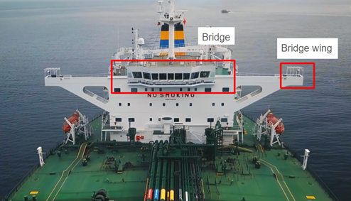
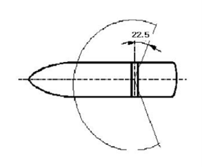
The centrally positioned bridge is generally positioned towards the top of the superstructure with the clearest view ahead with a minimum of 255 degrees of vision (including at least 22.5 degrees of visibility abaft the beam on both the port and starboard sides).

Adjacent bridge wings extend beyond the main bridge to provide a clear view of the port and starboard sides of the vessel together with with engine, stern and bow thruster controls during docking.
The ship’s bridge is always manned by an officer of the watch, who has the responsibility of manoeuvering the vessel and coordinating with the engine room. In general, an officer and a lookout are required to be present on the bridge.

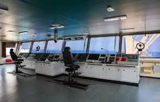
- Conning Position: Located at the forefront of the bridge, this area provides the helmsman with an unobstructed forward view. The steering wheel or joystick controls, along with a compass repeater, are positioned here for precise course control.
- Chart Table: A dedicated workspace for plotting the ship's course and position using nautical charts and publications.
- Navigation Consoles: These house a multitude of electronic navigational equipment, typically arranged for optimal access by watch officers.
Essential Navigational Aids:
- Electronic Chart Display and Information System (ECDIS): A digital navigation system displaying electronic charts overlaid with real-time vessel position and surrounding data.
- Radar: Provides a visual representation of the surrounding environment, aiding in collision avoidance and navigation in low-visibility conditions.
- Automatic Identification System (AIS): Transmits and receives information on other vessels in the vicinity, enhancing situational awareness.
- Global Positioning System (GPS): Provides highly accurate position data for precise navigation.
- Gyrocompass: A primary compass unaffected by the ship's magnetism, offering continuous heading information.
- Echo Sounder: Measures the water depth below the keel, crucial for avoiding grounding.
- Speed Log: Measures the ship's speed through the water.
- VHF Radio: Used for vital communication with other vessels and shore stations.
Additional Equipment:
- Anemometer: Measures wind speed and direction.
- Magnetic Compass: A backup compass for redundancy.
- Searchlights: Used for illumination and signaling in low-visibility situations.
- Communication Consoles: Facilitate communication with the engine room, crew, and external parties.
- Ergonomics: The layout prioritizes ease of use and minimizes fatigue for watch officers during long navigation shifts.
- Unrestricted Visibility: Large windows ensure a clear panoramic view of the surroundings.
- Redundancy: Critical equipment has backups to maintain functionality in case of failure.
- Lighting: Red or filtered white lights with dimming capabilities should be used to maintain visibility at night with anti-glare windows.